Texas · scanning live
AI SEVERE WEATHER INTELLIGENCE · TEXAS ONLY · FOUNDING PRICING OPEN
Know what hit the roof — before the adjuster says nothing did.
Type a Texas address. Get the storm, the date, and the hail size, traced to the radar scan that saw it — radar-verified, NWS-corroborated. 30 seconds.
No account needed for your first look.
Try: ·


Per-address pricing vs flat
Everyone else charges you by the address. We don't.
What everyone else charges · per address
Map-only subscriptions · no parcel-level report
Ten addresses a month runs $350–$500 with the industry-standard reports — even the budget tier is $150. That's why most reps only pull a report after a claim is already in trouble.
BeyondClaim Pro
lookup
Unlimited lookups · $29.99/mo flat
One address or four hundred — same price. Check the street before you knock it.
First 5 properties free, for life.
No card, no demo.
Competitor prices as published August 2026 · CoreLogic WVS · HailStrike · HailTrace · WeatherGuidance · Interactive Hail Maps · HailPoint
CoreLogic rate is the standard price announced effective June 10, 2026. Vendors without published pricing (OneClick Code, GAF WeatherHub, StormerSite) are not listed.
See it work
The whole loop, end to end.
The storm on a map, every roof it hit, the street on your phone, and the job carried to roof done. Real screens, not mockups.
- 01
Storm maps
The swath, the peak, the hardest-hit ZIPs — the morning after.
- 02
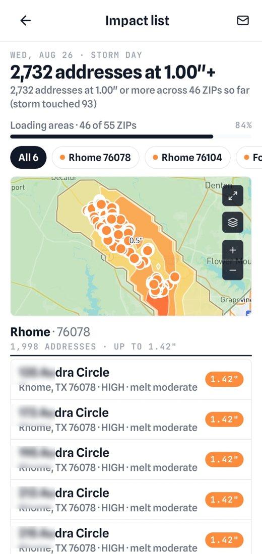
Impact list
Every address under the swath, with the hail size at each roof.
- 03
Live canvass
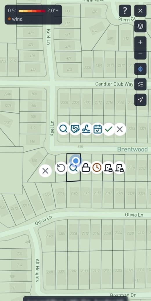
The street on your phone. One tap a door.
- 04
Door knock
The property sheet at the door — hail size, date, homeowner.
- 05
Roofing CRM
Agreed, contract signed, scheduled, roof done.
- 06
Live alerts
Enroll the ZIPs and counties you work — push and email within minutes. Pro and Team.
Sample report
Don't take our word for it. Read an actual report.
A real BeyondClaim report for Plano Municipal Center — 1520 K Ave, Plano, TX — generated straight from the radar archive. Page 1 is the property impact summary: 25 impact events at this parcel since 2021, 7 of them hail with a 1.75" peak in April 2023, each traced to its radar scan with the NWS report where one exists and a confidence score. The full 58-page history follows. Real radar detections, real timestamps, real sourcing. No signup, no email.
58 PAGES · REGENERATED AS THE ARCHIVE GROWS
The output, not the animation
Every radar scan resolves to one verified record.
The globe scans for effect — your report doesn't. Drop a Texas address and BeyondClaim pins the exact storm that crossed the property, the peak hail over it, and a confidence score, every figure traced to the radar scan it came from.
Confidence-scored
Each verdict carries a HIGH / MED / LOW score from the underlying radar quality — no black-box yes/no.
Sourced to the scan
Down to the radar station and scan count — defensible the way an adjuster needs.
Exportable in seconds
A clean PDF evidence report, ready to attach to the claim file.
1520 K Ave, Plano, TX 75074
33.0208°N, −96.6987°W · COLLIN CO.
PEAK HAIL · AT THIS ROOF
1.75"
Apr 20, 2023 · 2:25 PM CDT
13 radar scans · NWS report 3.00" at 1.5 mi
100% confidence · HIGH
When you'll use it
The moment it hits, before you knock, and after the carrier pushes back.
The moment it hits
“Did that storm just cross my territory?”
Enroll the ZIP codes and counties you work and live alerts email you when severe weather hits them — storm to inbox in minutes, not the next morning. Then open Storm maps for the full hail swath and the hardest-hit areas — and tap Canvass mode: drive the swath with live GPS, see which hail band you're in and what's ahead, get directions to the core. Pro and Team plans.
Before you knock
“Which houses on this street actually got hit — and on what date?”
Free swath maps tell you a neighborhood got hail. They don't tell you which house. Run every address on the route before the crew rolls out — checking costs you nothing.
After the carrier pushes back
“The adjuster says there was no qualifying hail at this address. Was there?”
Get the peak hail over that specific property, the exact date and time window, which radar station saw it and how many scans, and a confidence score. Attach it to the file. If the radar doesn't support the loss, you find out in 30 seconds instead of three weeks.
Door knock · included in Pro and Team
Don't buy leads. Knock the roofs the hail hit.
Same storm, two roofers. One is on the street the morning after with every hit roof on the phone. The other is waiting for a list that every competitor also bought.
With BeyondClaim
the storm is the list
T + 3 min
The alert lands
Your watched ZIPs. Push and email.
T + 10 min
Impact list is ready
Every roof under the swath, hail size at each.
The morning after
On the street
Canvass holds the house, lot lines and all. One tap a door.
That night
Follow-ups queued
Callbacks on their day, a reminder at each stage in the CRM.
With a bought list
days later, everyone has it
Days later
A file gets compiled
From whatever the vendor had on hand.
Then
Sold to everyone
Every roofer in the market gets the same one.
When it lands
Already stale
Half the street has been knocked twice.
At the door
Nothing
No history, no other crews, no next step.
We never collect homeowner names, phones or mailing addresses to sell. What you enter at Agreed stays with your company.
How it works
From address to audit-ready evidence
No forms, no guesswork. Enter a Texas address, we scan the archived radar over that exact property, and hand back a sourced report.
Enter an address
Type any Texas address and pick the event window. We pin the property's actual boundary — not just the middle of a ZIP code.
We scan the radar
Archived radar scans are matched to the property — hail size, gust speed, rotation — scan by scan.
Get the report
A PDF with the peak metric, confidence score, radar imagery, and every source listed for an adjuster to audit.
Why parcel-level matters
“No hail on that date” is the most expensive sentence in roofing.
You knocked the door, wrote the estimate, filed the claim. Then the desk adjuster pulls a ZIP-level weather summary and says nothing hit the property. BeyondClaim gives you the radar for the parcel, not the ZIP: the scan, the station, the time, the size, and the NWS ground report that backs it up. “Somewhere near here” isn't evidence.
Free swath maps
A colored blob over a few square miles. Good for picking a subdivision. Useless for a specific roof.
NOAA Storm Events
Free and genuinely useful — but it lands about 75 days after the end of the data month, it's compiled from media, law enforcement, and private individuals, and NCEI states the data may be unverified by the NWS. Most importantly, it only records hail somebody bothered to report — whole residential swaths generate zero entries. NCEI Storm Events FAQ
3-mile-radius reports
Some paid reports cover a 3-mile radius around the address. That's 28 square miles of answer to a one-roof question.
BeyondClaim
We match the archived radar scans against the property's actual boundary. Not the middle of a ZIP code. Not a radius. The lot.
Inside every report
Evidence an adjuster can audit
Every figure cites its source — the radar station, the scan count, the time window, and the raw radar data behind it. An adjuster can trace any number back to its source, which is the whole point.
Auditable source list
Radar station, scan count, time window, and the raw radar data behind every figure — trace any number back to its source.
Confidence you can read
HIGH, MEDIUM, or LOW, scored from radar quality and cross-referenced against official ground storm reports — not a black-box yes/no.
“None detected” is a real answer
If the radar doesn't support a loss at that address, the report says so — before you burn a supplement and an adjuster relationship.
Your searches stay yours
CCPA compliant. Addresses you look up are never sold, shared, or used to train any model.
sample-report.pdf · 1520 K Ave, Plano
EVIDENCE REPORT · AUDIT-READY
PEAK HAIL · AT THIS ROOF
1.75"
Apr 20, 2023
2:25 PM CDT · NWS report 3.00"
CITED SOURCES · 4
Honest limits
What this is — and what it isn't.
This category has oversold contractors for years. Here is exactly where BeyondClaim's job ends.
Your first-call tool
BeyondClaim tells you fast, and cheaply, what the radar shows at an address — whether a loss is supportable, and which date to argue.
Not a signed meteorologist's opinion
No instant, algorithmically generated report is — nobody's. When a file goes to appraisal or litigation and needs a credentialed meteorologist to certify it, that's a separate, weeks-long engagement. BeyondClaim tells you whether you're likely to need one — and exactly which date and time window to have certified.
Probabilistic by nature
Weather data deals in probability, not certainty. Reports are evidence for your review, not a guarantee of any claim outcome — the carrier decides that.
Methodology
Six severe weather types. One radar engine.
Each event type is verified against the right radar product — hail, wind, tornado, flood, winter, hurricane. For the skeptics: the tag on each card is the actual radar product we read, and every query runs all six.
Hail
Maximum Estimated Size of Hail per radar sweep, intersected with parcel polygon.
Threshold > 1.0"
Wind
Peak gust velocity from radial Doppler velocity at the lowest tilt angle.
Threshold > 58 mph
Tornado
Tornadic Vortex Signature plus confirmed track polygons.
Any EF rating
Flood
Quantitative Precipitation Estimate over rolling windows + FEMA flood zone overlap.
Threshold > 2"/hr
Winter
Snow Water Equivalent + ice accumulation from dual-pol radar correlation.
Threshold > 6" snow / 0.25" ice
Hurricane
Official forecast cone + best-track wind swath at parcel coordinates.
Cat 1 and above
Built for
Contractors first. Adjusters and appraisers too.
Contractors
Check any address before you knock — it costs nothing to look. Confirm the date of loss before the supplement goes in, and hand the homeowner a sourced report on the spot.
Adjusters
Cross-check a claim against the radar in seconds. Confidence-graded so you know what to escalate and what to close.
Appraisers
Pull cited radar evidence for a property claim — dates, peak sizes, and sources an adjuster can audit.
Founding pricing
Simple. Published. Everything included.
Most of this industry won't tell you what anything costs until you sit through a demo. Here's ours — founding pricing. One plan buys the report, the storm and the street: StormProof, Storm maps with the impact list, live alerts, Door knock and the roofing CRM. Your founder rate stays locked while you're subscribed, and every state we add is included at that same rate. New signups pay more once we expand.
Starter
Try it free — no credit card required
/ month · always free
Pro
For active contractors
/ month · rate locked while subscribed
Team
For crews & agencies
/ month · rate locked while subscribed
| What you get | Starter | Pro | Team |
|---|---|---|---|
| Verify · StormProof | |||
| Property lookups | 5 free for life | Unlimited | Unlimited |
| All six perils, 5+ years of radar | ✓ | ✓ | ✓ |
| Audit-ready PDF report | ✓ | ✓ | ✓ |
| Find · Storm maps | |||
| 30-day storm timeline + hail swath | — | ✓ | ✓ |
| Impact list: every roof it hit, hail size at each | — | ✓ | ✓ |
| Live alerts for your watched ZIPs | — | ✓ | ✓ |
| Work · Door knock + roofing CRM | |||
| Canvass at house level, lot outlines statewide | — | ✓ | ✓ |
| Roofing CRM: inspected to roof done, a reminder per stage | — | ✓ | ✓ |
| Other crews' signed jobs and Do not knock, marked for everyone | — | ✓ | ✓ |
| Crew | |||
| Seats | 1 | 1 | 5 |
| Shared quota pool · audit log · bulk verify | — | — | ✓ |
No per-lead fees. No list to buy each storm. We never collect homeowner names, phones or mailing addresses to sell.
Or $6.99 per lookup, pay-as-you-go— if you'd rather not subscribe. Cancel anytime. No annual contract.
AVAILABILITY · TEXAS ZIPS ONLY · OTHER STATES NEXT
Who's behind this
Built and backed by Kodeway Inc.
BeyondClaim is a Kodeway Inc product. We build it, we run it, and we answer for it — email contact@kodeway.com and you reach the team directly, usually within a day.
And we don't build it in a vacuum: working Texas roofers and contractors run BeyondClaim on real claims and tell us where it falls short. That feedback decides what we build next.
FAQ
Common questions
Do you sell leads?
No. Door knock gives Pro and Team crews every lot in the storm path with what your own crew did at each door, and the roofing CRM carries each job to roof done. Houses other companies have under contract are marked so you walk on. We never collect homeowner names, phones or mailing addresses to sell.
Where does BeyondClaim work right now?
Texas only for now. Oklahoma, Louisiana, and Florida are next. Sign up now and your founding rate stays locked while you’re subscribed — and every state we add is included at that same rate, automatically. No new tier, no upgrade, no price change when we expand.
How much weather history can I search?
More than 5 years — our radar archive reaches back to January 2021 — plus any live events going forward. The archive grows daily, so each month you gain another month of searchable history.
Does BeyondClaim alert me when a storm hits my area?
Yes — live alerts are included on Pro and Team. Enroll the ZIP codes or counties you work and you get an email the moment our storm intelligence confirms severe weather there, typically within minutes of the radar detection. Storm maps then shows the full swath and the hardest-hit areas for the day, so you know where to canvass before other crews finish guessing.
What is Storm maps?
A Pro and Team feature: a 30-day timeline of every Texas storm day, each with its hail swath map, peak size, and the hardest-hit cities and ZIP codes. It answers the prospecting question — where do I send crews — and every area links straight into an address-level verification. Canvass mode then puts it on the dash: drive the swath with live GPS, see which hail band you're in and what's ahead, and get directions to the core.
What storm types does BeyondClaim cover?
Six perils — hail, wind, tornado, flood, winter, and hurricane — organized into four report categories (hail + wind + tornado are bundled because they co-occur on radar; hurricane, winter, and flood run independently). A single address query runs all of them automatically, on every plan.
How is this different from the free hail map my supplier gives me?
Supplier maps show storm swaths — a colored polygon over a few square miles. That's useful for picking a subdivision to canvass, but it isn't evidence for a specific roof. BeyondClaim matches the archived radar against the property's actual boundary and traces every figure to the radar scan it came from. And most “free” tools aren't free — they're short trials or perks locked behind a certification tier.
Where does the weather data come from?
BeyondClaim's AI severe weather intelligence runs on the same primary government radar and observation feeds national forecasters use. Every figure in a report cites its exact source inline, and the full source list is linked in the footer of this page.
Isn't this just public NOAA data?
Yes — the same way Zillow is just public county records. Raw NEXRAD is terabytes of radar moments with no addresses attached. BeyondClaim decodes, calibrates, indexes, and corroborates it so that one address returns one answer in 30 seconds, with every figure cited to the scan it came from.
Will an adjuster accept this?
Reports cite the radar station, scan time, product (MRMS MESH or NEXRAD Level III), the NWS ground report, and the distance to the parcel — the same evidence chain a certified meteorologist would build. Radar-only detections are labeled separately from NWS-corroborated ones, and the report verifies that the weather occurred at the lot; it never claims damage.
How accurate is the confidence score?
Scored against the radar evidence — signature strength, size, source agreement, and distance — with cutoffs set per peril: High from 80–85% depending on the peril, Medium from 60–65%, Low below that. Confidence is not the same as corroboration: whether an NWS ground report backs an event is shown separately on every row. "None detected" is a valid and defensible result — we never inflate confidence to make a report look better.
Can BeyondClaim make up results?
No. Every figure — hail size, gust speed, event date — is tied to a specific radar scan and the property's boundary. If radar doesn’t support a result, the report says so. The system cannot invent a data point.
How much does it cost?
Your first 5 properties are free, for life — no card required and no monthly reset. Any property you have already searched stays free to re-open and re-download. Beyond the first 5: $6.99 per lookup pay-as-you-go, Pro for unlimited lookups, or Team for 5 seats with a shared usage pool. Founding-member rates stay locked while you’re subscribed and rise ~40% for new signups when we open beyond Texas.
Is there a limit on "unlimited"?
Fair use is 1,000 lookups a month — no contractor doing real work gets close to that (it's about 45 addresses every working day). If you somehow do, we'll talk to you before anything slows down. There's no per-address meter and no overage charge.
Can I cancel anytime?
Yes — no annual commitment, cancel whenever you like. Your first 5 properties are free — for life, no monthly reset — so you can verify the product works before you pay anything.
Is my data private?
Addresses you look up are never sold, shared, or used to train any model. In Door knock, the anonymous "do not knock" and "out of reach" markers are shared with other BeyondClaim crews as a yes/no only — never your company, the homeowner, or a date. BeyondClaim is CCPA compliant — you can request deletion of your account and lookup history at any time by emailing contact@kodeway.com. Your historical evidence is yours and persists as long as your account is active.
Who is BeyondClaim built for?
Anyone who needs to answer "what storm hit this address, and when?" — roofing and restoration contractors checking a street before they knock or defending a date of loss, insurance adjusters cross-checking claims against the radar, and appraisers assembling cited evidence for a property claim. If your work depends on knowing what the weather did at one specific address, it’s built for you.
No demo, no sales call
Check an address right now.
Five properties free, for life. No card required. If it doesn't tell you something useful in 30 seconds, close the tab.
Take it to the field
The full product — lookups, storm history, claim-ready reports — runs on your phone. Scan to install, or tap a badge.